After spending some time working with GIS files on a daily basis, I realized there’s no comfortable and practical tool for quickly inspecting or transforming files with georeferenced vector data. Having to write three lines of code in a script or in the Python interpreter every time I want to transform geometries feels like a lot, and the sluggishness of desktop applications like ArcGIS and QGIS has always felt like a waste of my life—the cooling fans on my computer say it’s a waste of its life too.
GDAL and OGR have always been the go-to tools for working on the command line, but their power and flexibility for handling both vector and raster data come at the cost of a steep learning curve that can be tough for new users. I enjoy working in the terminal, and since I never really found an intuitive, easy-to-use application, I decided to build my own to simplify the day-to-day tasks a GIS developer has to deal with—the ones that don’t call for designing and building a full-blown system.
This post is here to show how geoterminal’s capabilities can make a GIS developer’s life a whole lot easier.
geoterminal
geoterminal is a command-line interface tool to quickly inspect and transform geospatial data, letting users write less code and skip heavy software for quick operations.
Check out the GitHub Repository, and follow along this walkthrough to learn how to use it!
Walkthrough
Getting Started
Install it with pip, or check the Installation Guide for other options:
pip install geoterminal
Let’s start by creating a folder for this demo and downloading the shapefiles of the world’s countries, published by the World Bank:
# Create folder
mkdir geoterminal_demo
cd geoterminal_demo

# Download World Bank's shapefile zip
curl --output countries.zip https://datacatalogfiles.worldbank.org/ddh-published/0038272/3/DR0046659/wb_countries_admin0_10m.zip

# Unzip the file
# tar -xf countries.zip will do if you are using Windows
unzip countries.zip
Checking the contents of the WB_countries_Admin0_10m folder, we should see something like this:
❯ ls WB_countries_Admin0_10m
WB_countries_Admin0_10m.cpg
WB_countries_Admin0_10m.dbf
WB_countries_Admin0_10m.prj
WB_countries_Admin0_10m.sbn
WB_countries_Admin0_10m.sbx
WB_countries_Admin0_10m.shp
WB_countries_Admin0_10m.shp.xml
WB_countries_Admin0_10m.shx
File Inspection
Just by running geoterminal INPUT, we enter inspect mode, where we get options to quickly look into georeferenced files. geoterminal INPUT --head shows us the first 5 rows of data (--head N for N rows), and we can see the last rows using the --tail flag.
❯ geoterminal WB_countries_Admin0_10m/WB_countries_Admin0_10m.shp --head
Reading file with format: .shp
Getting first 5 rows
   OBJECTID       featurecla  LEVEL               TYPE                       FORMAL_EN FORMAL_FR  ...    WB_NAME  WB_RULES  WB_REGION  Shape_Leng  Shape_Area           geometry
0         1  Admin-0 country      2  Sovereign country           Republic of Indonesia      None  ...  Indonesia      None        EAP  495.029918  153.078608  MULTIPOLYGON(...)
1         2  Admin-0 country      2  Sovereign country                        Malaysia      None  ...   Malaysia      None        EAP   68.456913   26.703172  MULTIPOLYGON(...)
2         3  Admin-0 country      2  Sovereign country               Republic of Chile      None  ...      Chile      None        LCR  416.997272   76.761813  MULTIPOLYGON(...)
3         4  Admin-0 country      2  Sovereign country  Plurinational State of Bolivia      None  ...    Bolivia      None        LCR   54.345991   92.203587       POLYGON(...)
4         5  Admin-0 country      2  Sovereign country                Republic of Peru      None  ...       Peru      None        LCR   73.262192  106.417089  MULTIPOLYGON(...)

[5 rows x 53 columns]
We can get the coordinate reference system (CRS) of the files (if it’s present) with the --crs flag, and we can check the column data types with the --dtypes flag, just like in pandas.
❯ geoterminal WB_countries_Admin0_10m/WB_countries_Admin0_10m.shp --dtypes
Reading file with format: .shp
Getting data types information
Column data types:
  OBJECTID: int64
  featurecla: object
  LEVEL: int32
  TYPE: object
  FORMAL_EN: object
  FORMAL_FR: object
  ...

❯ geoterminal WB_countries_Admin0_10m/WB_countries_Admin0_10m.shp --crs
Reading file with format: .shp
Getting CRS information
CRS: EPSG:4326
File Conversion
By default, geoterminal’s will convert files between formats: geoterminal input.shp output.geojson.
geoterminal WB_countries_Admin0_10m/WB_countries_Admin0_10m.shp countries.geojson
This feature comes in handy when you want to work with other tools that require specific file formats, like kepler.gl. kepler.gl is a great web-based app for quickly uploading and visualizing GIS data. While it doesn’t support shapefiles, we can upload our freshly converted countries.geojson and see our results in action.
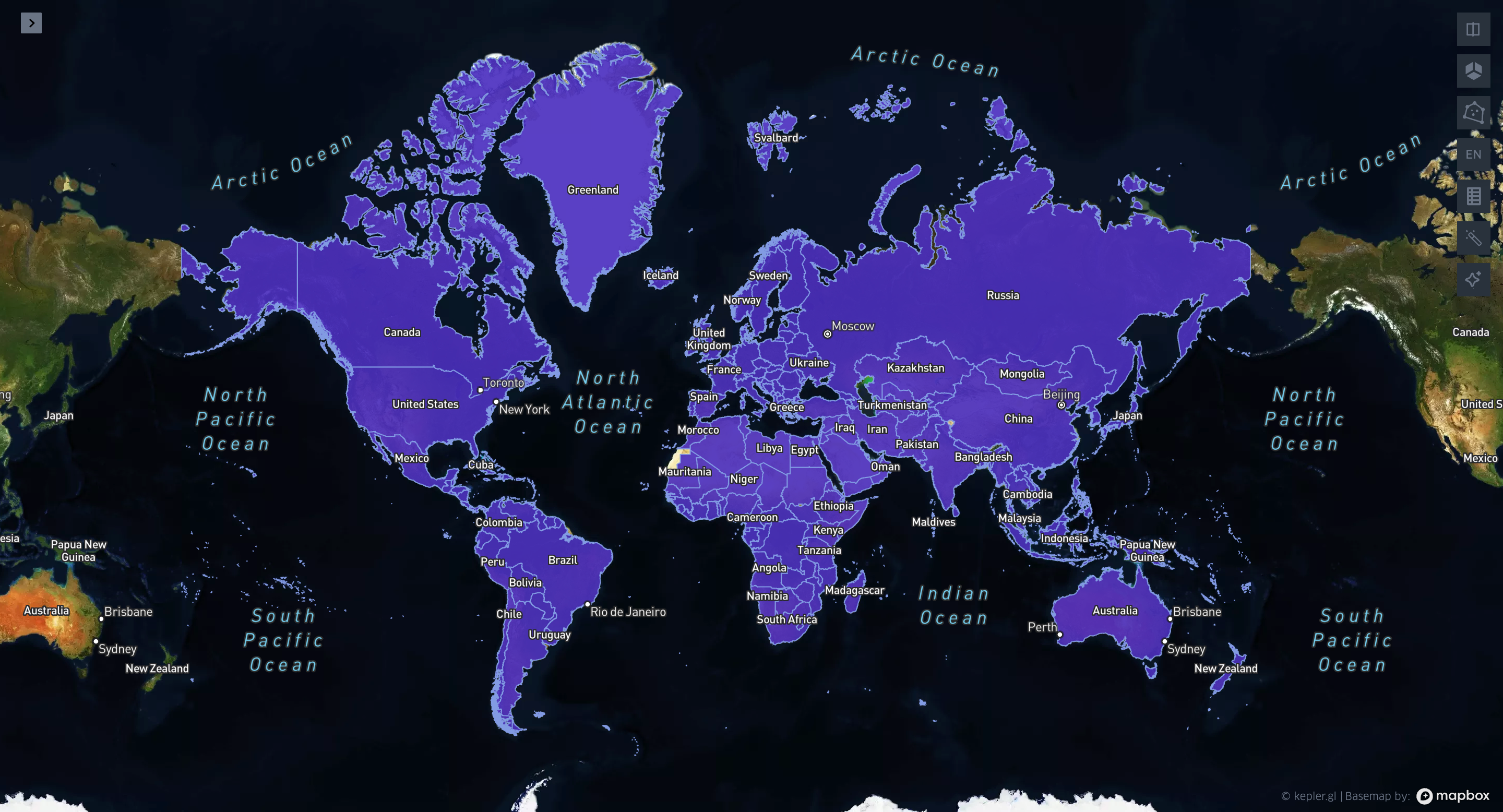
Sweet!
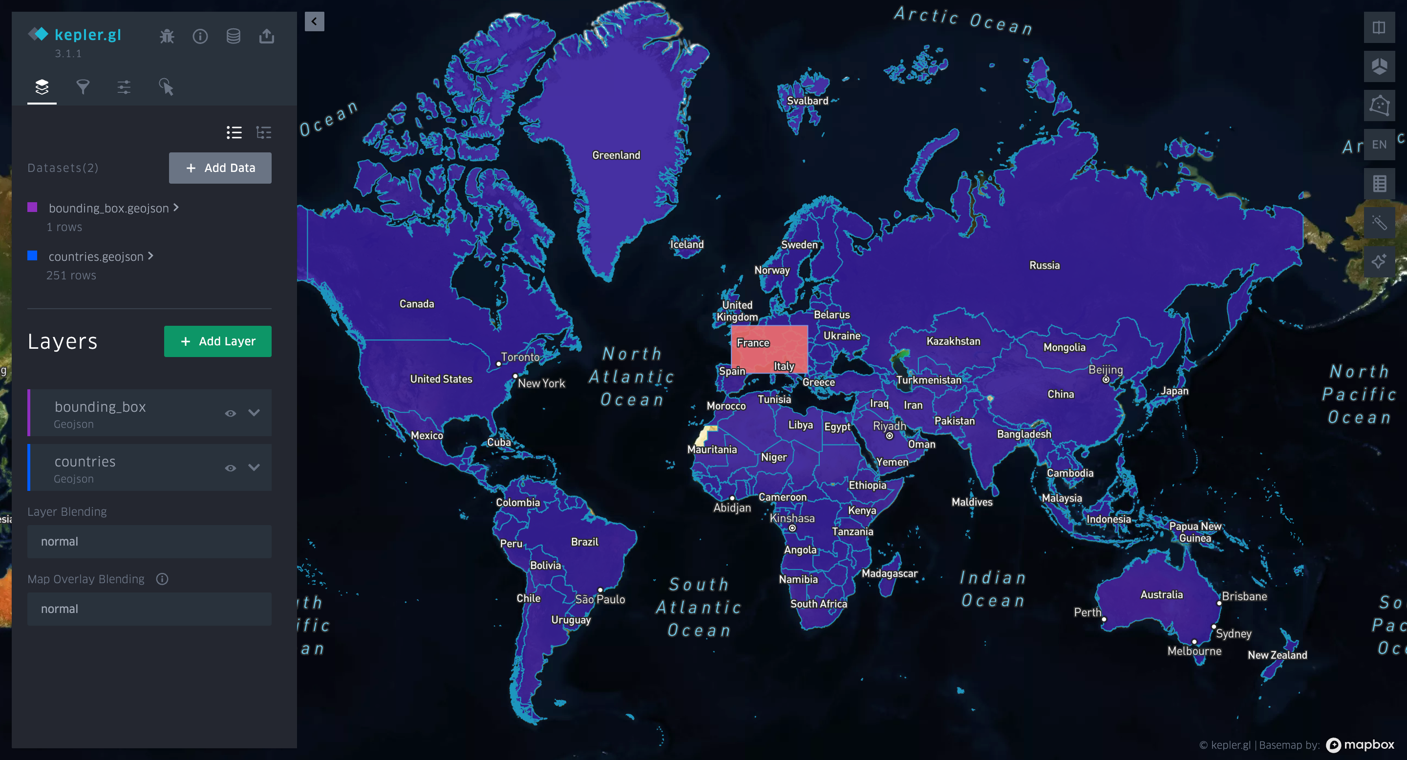
geoterminal accepts geometries in Well-Known Text (WKT) format as input—essentially, geometries represented as a string, like this:
POLYGON((-4.32 51.96, 20.29 51.96, 20.29 41.46, -4.32 41.46, -4.32 51.96))
This represents a bounding box around Europe that I just created using a tool called BoundingBox.
I can take that string and use geoterminal to convert it into a GeoJSON file:
geoterminal "POLYGON((-4.32 51.96, 20.29 51.96, 20.29 41.46, -4.32 41.46, -4.32 51.96))" bounding_box.geojson
Let’s keep going!
Transformations
geoterminal really shines when we need to perform operations on the fly. The tool supports a variety of geometric operations, such as intersections, clips, buffers, simplifications, centroid calculations, and more. And it even includes H3 hexagon tessellation!
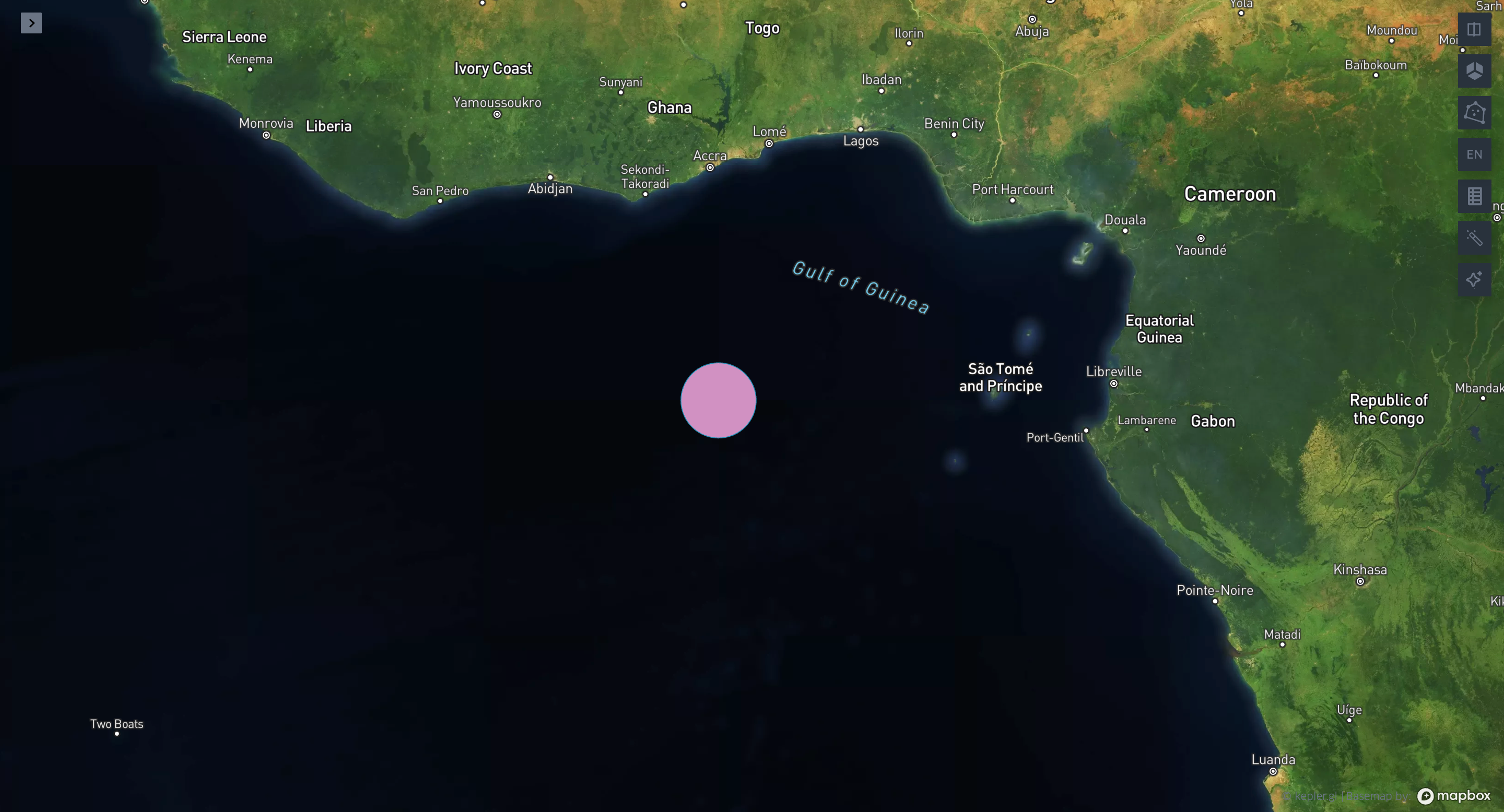
For example, let’s buffer a point in the middle of the Gulf of Guinea:
geoterminal "POINT(0 0)" buffered_point.geojson --buffer-size 100000
For a more practical use case, let’s take the countries.geojson file and apply the --intersects flag with the newly created bounding_box.geojson. This will generate a new file containing only the countries that intersect with our bounding box, like this:
geoterminal countries.geojson intersected.geojson --intersects bounding_box.geojson
We can also perform a clip operation using the --mask flag, which will remove parts of the countries’ geometries that fall outside the bounding box:
geoterminal countries.geojson masked.geojson --mask bounding_box.geojson
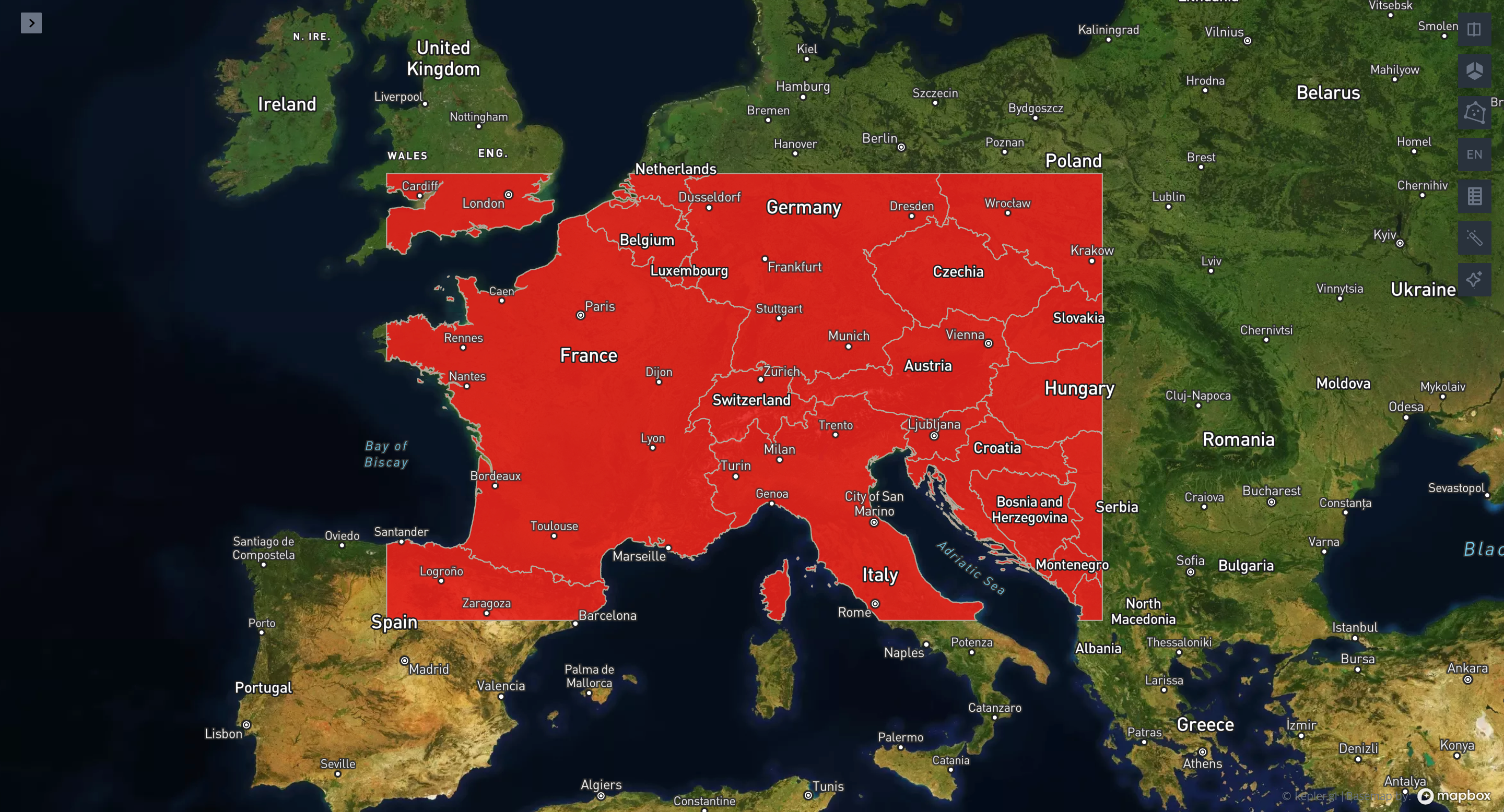
The --intersects and --mask arguments can also accept WKTs, meaning we can directly perform these operations without needing to convert the bounding box WKT into a file:
geoterminal countries.geojson intersected.geojson --intersects "POLYGON((-4.32 51.96, 20.29 51.96, 20.29 41.46, -4.32 41.46, -4.32 51.96))"
geoterminal countries.geojson masked.geojson --mask "POLYGON((-4.32 51.96, 20.29 51.96, 20.29 41.46, -4.32 41.46, -4.32 51.96))"
Here are a few more commands you can try to explore the various geoterminal operations:
geoterminal countries.geojson filtered.geojson --query "SUBREGION=='South America"
geoterminal countries.geojson centroids.geojson --centroid
geoterminal masked.geojson buffered.geojson --buffer-size 1000000
Check the documentation for all the supported operations.
Now to the real thing:
Chaining Operations
geoterminal’s most powerful feature is its ability to chain operations. All flags (--command) are executed sequentially while transforming the INPUT into the OUTPUT.
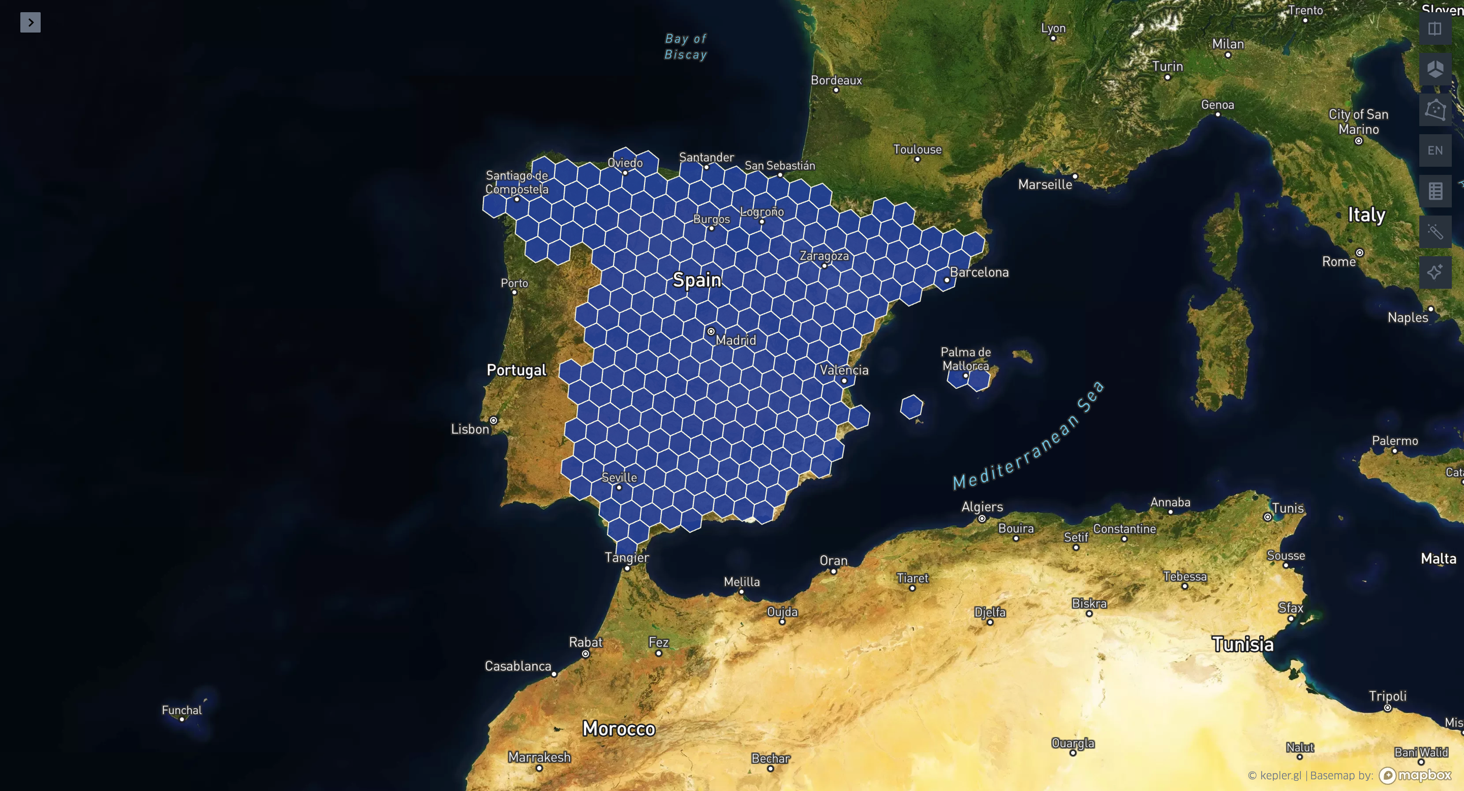
For example, let’s say I want to filter Spain from our data and transform the country’s geometry into H3 hexagons at resolution 4. I can easily do this in geoterminal using the --query command, followed by the --h3-res command, like this:
geoterminal countries.geojson spain_h4.geojson --query "WB_NAME=='Spain'" --h3-res 4
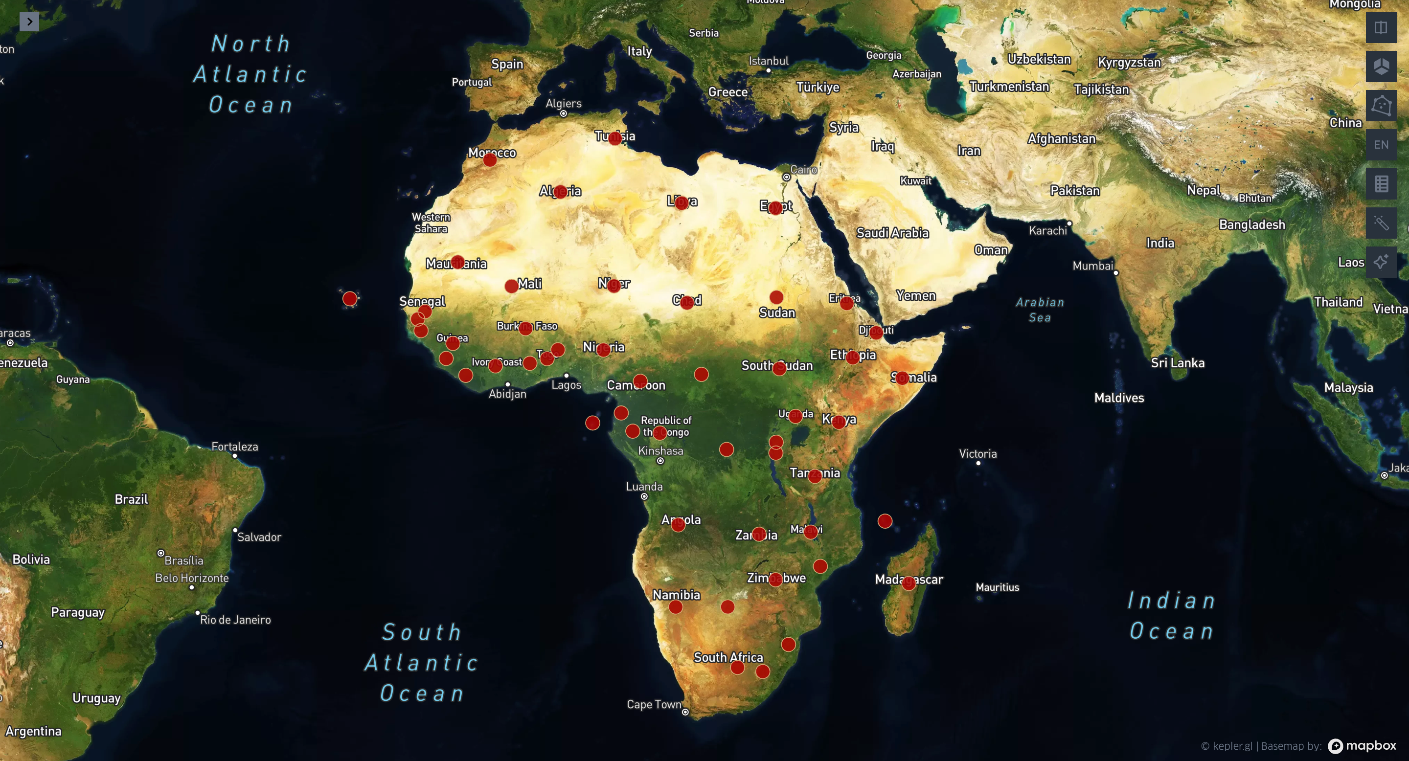
Now, let’s filter all the countries in the African continent, calculate the centroid of each country, and then apply a 100-kilometer buffer:
geoterminal countries.geojson african_100km_buffers.geojson --query "SUBREGION=='Africa'" --centroid --buffer-size 100000
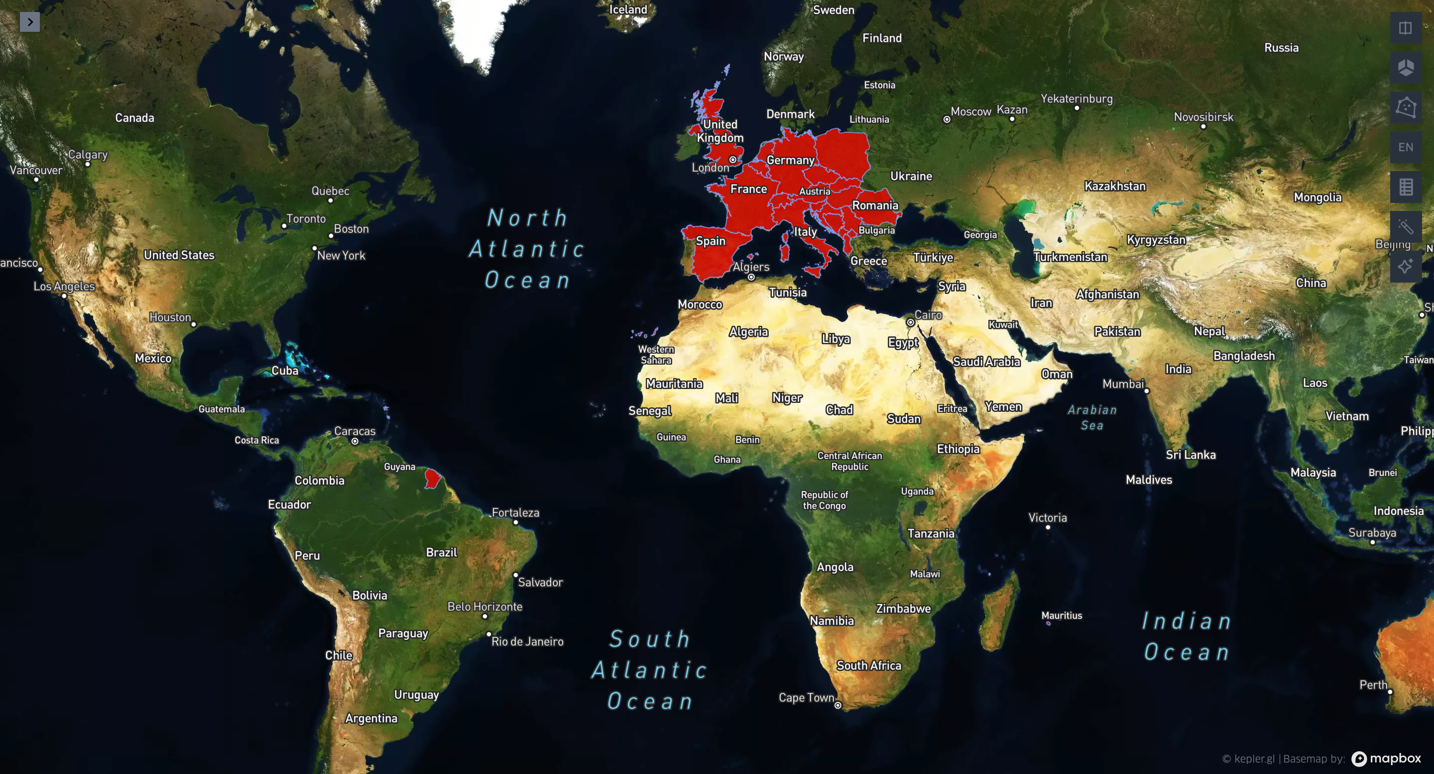
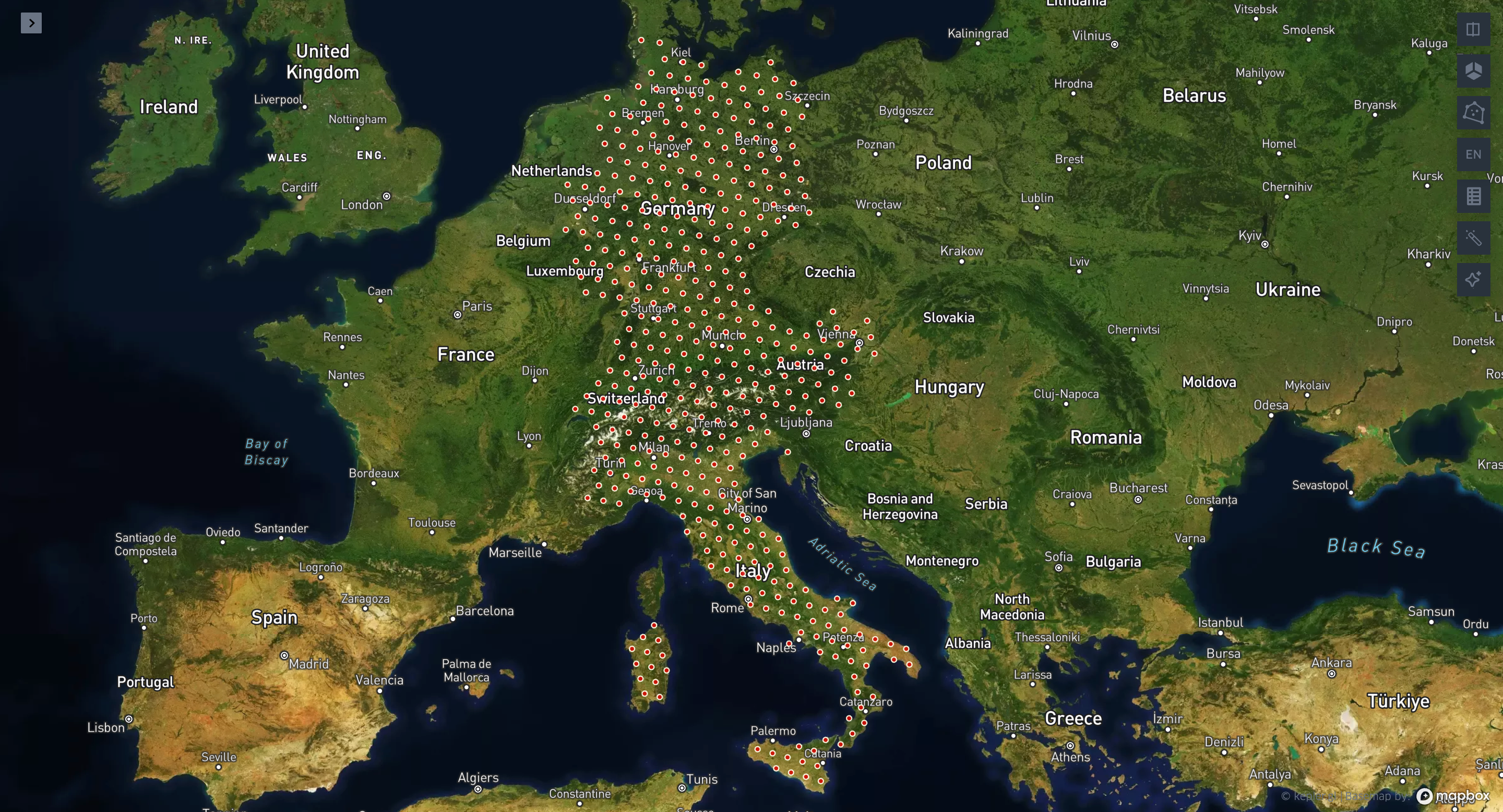
Final example! Let’s filter Germany, Italy, Switzerland, and Austria, generate a mesh of H3 hexagons at resolution 4, calculate the centroids of those hexagons, and apply a 10-kilometer buffer:
geoterminal countries.geojson long_chain.geojson --query "WB_NAME in ('Germany', 'Italy', 'Switzerland', 'Austria')" --h3-res 4 --centroid --buffer-size 10000
Conclusion
Thanks for reading! geoterminal is a work in progress, and like most open-source projects, it thrives on community input. It’s still under active development, so if you have ideas, use cases, or want to help push the project forward—jump in!